Relentless Passagemaking
(Or, the long slog north!)
Visas were expiring. The eclipse was coming. It was time to reluctantly turn the bow north. So the dinghy got secured on deck and the float plan updated. And on the morning of March 5, we picked up the hook under sail in Elizabeth Harbour for the last time this season.

Last bowsprit perch in the Bahamas this season
One of the lessons that’s hit home time and time again this winter is that generally, if you wait a while, you’ll get great wind to sail in whichever direction you want to go. A little patience will net you some excellent progress with very little engine run time. We’re fans of this approach (perhaps underscored by the modest capacity of the fuel tank) and spent a lot of time this season fine-tuning it. We sailed everywhere. Off anchor, on anchor, everywhere in between. There was a lot of tacking practice as we sailed upwind, but mostly our sails were glorious, gorgeous, beam reaches or dead downwind runs. We put 50 hours on the engine between December 3 and March 10, and not because we were stuck in one place. Even our 10 days in George Town saw us sailing in the harbor almost every single day.
It’s a mystery to us when we see boats motoring straight into the wind when waiting one more day would have afforded a downwind sail.
But I digress.
That northward trip, had we been able to wait a couple of months, might likely have been a straight 5 day shot direct to Beaufort, North Carolina. As it was, we needed to do more of a combination of day hops and longer offshore jumps, aiming to use that engine as infrequently as possible. Our tracker, especially once we got back to the US, shows just how challenging it’s been.

Inside, outside.
March 5: George Town to Black Point. Sailing.
March 6: Black Point to Shroud Cay. Sailing.
March 7: Shroud to Highbourne (with an all-too-short fly by conversation with Pinky and Charlie on Loka). Sailing.
March 8: Highbourne to Rose Island. Sailing.
March 9: Rose Island to Bonds Cay, Berrys. Sailing.
March 10: Bonds Cay to Snake Island at Great Stirrup Cay (with a glorious fly by conversation at Shell Beach with Kimberly and Mike from Ally Cat) Sailing.
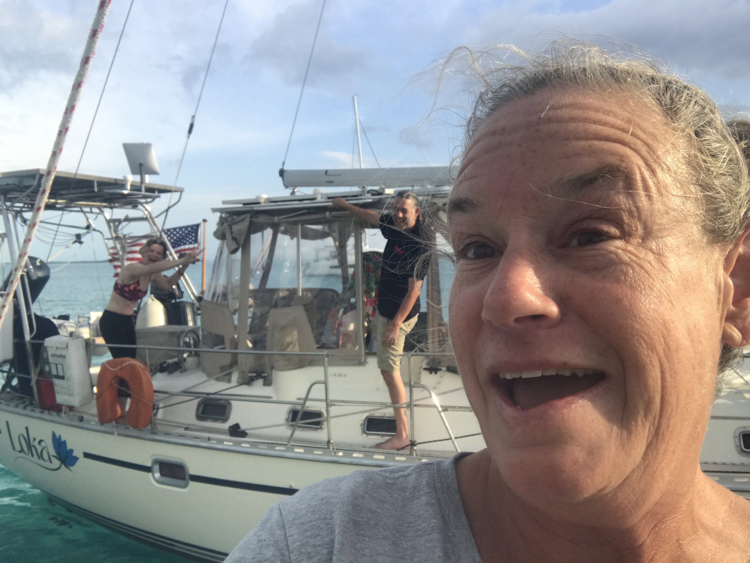
Fly by with happy people in the photo
Here we sat for a couple of nights, waiting out a cold front. The anchorage was not particularly scenic - Great Stirrup and its close neighbor, Coco Cay, are owned by cruise ship companies and landing is expressly prohibited. Coco Cay has been completely terraformed into what looks through the binoculars to be an amusement park. No joke. There’s a huge water slide, a hot air balloon, a couple of ziplines, an armada of blue beach chairs ready to be deployed on the one remaining stretch of sandy beach . . .
We needed a stretch of easterly/southeasterly sector winds to make it across the Gulf Stream, ideally a long enough stretch to be able to ride the Stream north to the Florida/Georgia border. We’ve heard such great things about Cumberland Island National Seashore and thought this might be our best chance to see it. Plus, the 3 knot northerly current in the Stream would give us a wonderful boost!

Last Bahamas sunset, the amusement park sort of visible
March 12, 13, 14: At sea. Mostly sailing, with some motoring thrown in when winds got too light.
We picked up the anchor at Snake Cay just pre-dawn on March 12, heading for the St Mary’s Inlet. 400 miles give or take. Winds were forecast to be super light but from the right direction. And indeed, they were incredibly light. Our rule of thumb is that when the boat speed drops below 2 knots, we’ll fire up; we had to fire up. Three days later, though, we cleared the jetty at St Mary’s and dropped the hook in Fernandina Beach while waiting for our customs clearance to come through.
An hour later, realizing the fuel dock had no fuel and looking for a more picturesque place to spend the night than Fernandina Beach with its paper mills and perfect wind direction for wafting their olfactory treats our way . . . off we went to Cumberland, an hour and a world of difference away.

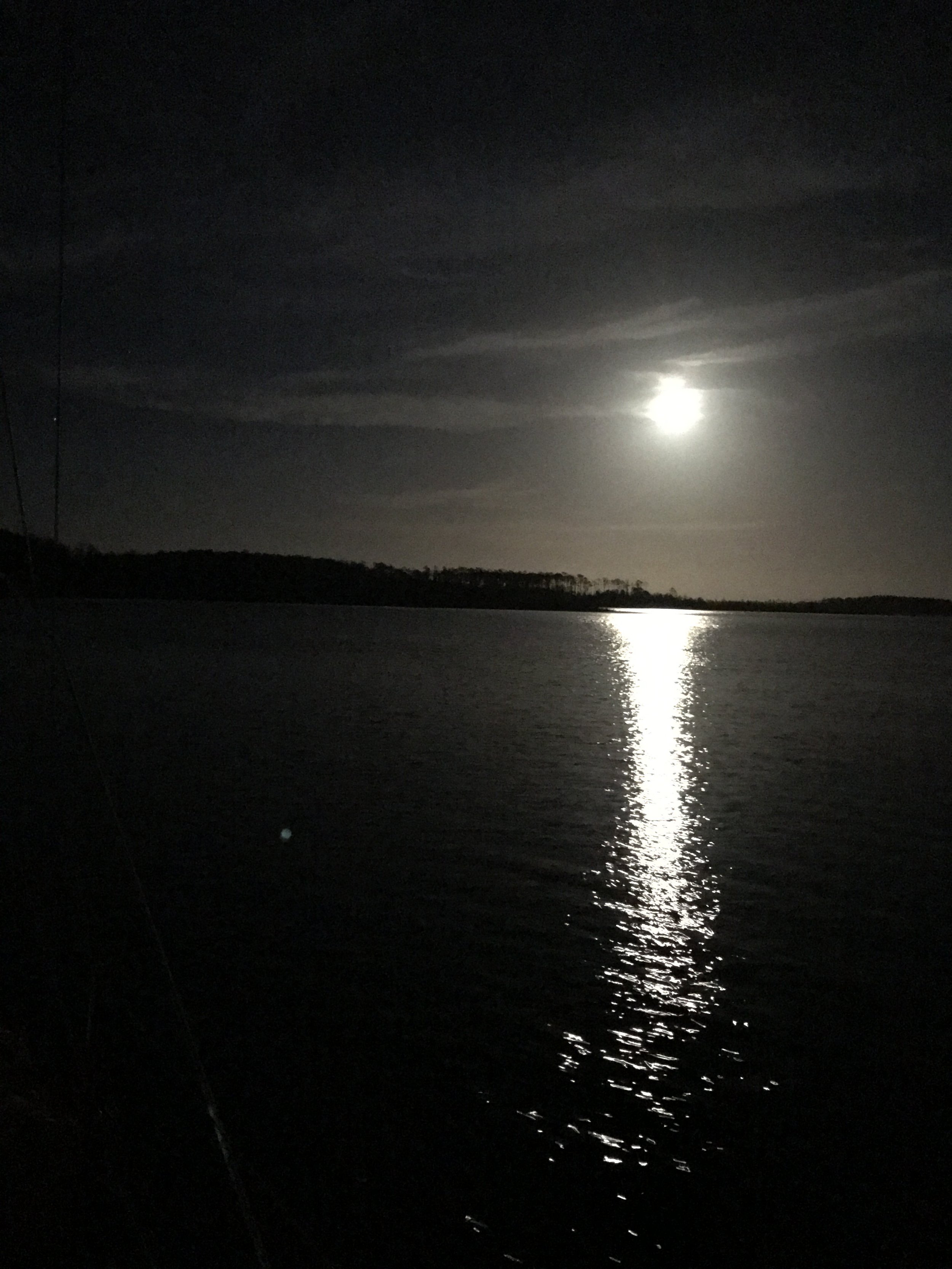
Sailing west, the sliver of moon on the tip of the pole
March 15: Cumberland Island (mm 708 or so)
.That afternoon was a blur of naps and recovering from the passage. Our hike ashore would be the next day, we reasoned.
And it was.

The Park Service has a fabulous sense of humor
And later THAT afternoon? We picked up the hook and headed offshore again, headed for Charleston.
March 16: at sea. Motorsailing to keep speed up.
March 17/18: Lady’s Island Marina, Beaufort, SC (pronounced BEW-fort), mm 536
The ICW runs from mile 0 at Norfolk, Virginia, down to mile 1096 at Miami, Florida, and offers a protected inland waterway for boaters trying to move north or south along the coast. It’s great in many situations - but it’s not a good idea to run at night. It’s narrow and current-prone, making sailing difficult to impossible. It also, especially in the Georgia and South Carolina sections, is incredibly twisty, adding huge numbers of miles to the journey. There are a number of opening bridges to contend with, some with restrictive opening schedules. We figure a 50 mile day is a good run, and it’s tiring.

All inside . . .
The St Marys Inlet (right at the Florida/Georgia border) is at mile marker 714. The Charleston Inlet? Mile marker 464. To sail directly between the 2? 150 miles. Granted, the mile markers are in statute miles and the direct run mileage is nautical (a nautical mile is slightly longer than a statute mile), but any way you slice it it’s an incredible savings of distance and time.
Still, we were keeping an eye on weather. It looked like we had until 9 pm Sunday night before a torrent of thunderstorms hit us, so getting in before then was our goal. We noted the inlet options in case we didn’t make good speed but spent some time researching a marina so we could have good showers and easy access to grocery shopping and laundry.
Spoiler alert - we chickened out. More precisely, I chickened out. Reviews of the marinas in Charleston were fairly horrible due to wakes and current. We’d be coming in late at night, needing to navigate a busy harbor in the dark with city lights confusing the issue. Whichever our chosen marina wound up being, it would be expensive - and we’d spend one night at the dock with nothing to show for it except a hefty bill. Plus, we prefer smaller towns to huge cities.
So we ducked into Port Royal Inlet (mile marker 548 - north of Brunswick on that map) and into Beaufort, South Carolina (mm 536), where we booked a slip at the (slightly) less-pricey Lady’s Island Marina where my friend Kimberly is the dock master. Showers, laundry, a courtesy car . . . I had a load of laundry done before dinner. Despite needing to run the engine for those twists and turns of the last 12 miles or so, it felt like a pretty good choice.
March 19: at sea. Sailing.

As we went north, the layers piled on
After 2 nights at Lady’s Island, with clean clothes, a stocked fridge and pantry, and after a package arrived with a new SIM card for Jeremy’s phone and a last shower, we shoved off the dock still not sure if we were just heading inside or going back offshore. The weather window was short, supposedly slamming shut with a vengeance on Wednesday night around sunset. We might make it to Cape Fear . . . Once again we marked the inlet options and after checking and rechecking the weather forecast, headed offshore through the St Helena Sound inlet.
Much of the night was spent sailing downwind under double-reefed main alone. It was blowing a steady 20-25 knots; the shallow waters off the coast combined with those wind strengths to form some very impressive waves. The boat did amazingly well, surfing at speeds of up to 10 knots on more than one occasion. We were VERY happy we were not trying to go the other direction!
Just before dawn we reached the Winyah Bay Inlet (mile marker 406 - Georgetown on the map) and decided to duck back inside. The night had been a little tougher than anticipated and it looked like the weather would turn nasty just as we approached the Cape Fear River. (mm 308) Increasing winds against a strong current as it got dark with 10 miles (2 hours) to go to reach a protected anchorage . . . nope. Inside we went.
March 20: Anchored at Waccamaw River, SC (mm 374)
Woulda shoulda coulda. Of course, right? The forecast weather didn’t materialize until Thursday morning. The winds calmed down almost as soon as we made the decision to go inside. Rather than being at mile marker 308 (or further!) on Wednesday night, we were at 374. Oh well. We had the hook down and were showered, fed, and in bed by 6:30 pm. Yeah, way before dark.
Unfortunately, going on the ICW means sailing is almost non-existent. If you’re lucky, you can roll out a jib or pull up the main to assist with the diesel drone, but usually it’s too narrow and twisty to sail even if the wind is from the right direction. This trip, we went inside to be able to make progress even when the wind offshore would have made it impossible. Which means mostly we were motoring directly into the wind. Sigh.

Refueling underway
March 21. Southport, North Carolina (mm 311).
March 22. North side of the Figure Eight Swing Bridge at mile marker 278.
All this time, we’re keeping an eye on the weather (are you getting the idea that weather rules all? You’d be right.) as well as endlessly poring over charts and the excellent ICW cockpit reference guide from The Boat Galley, looking for good anchorages for protection from forecast winds. Though there are lots of anchorage possibilities along most stretches of the ICW, they aren’t always in easy reach of each other. Sometimes this means we have to cut our days short. Like this one, where we only made 33 statute miles of progress. No matter. We had good internet and needed to get in some computer time anyway.
March 23: Mile Hammock Bay (mm 244)
Another short day. It was this or press on another 20+ miles (4 hours), with the weather forecast to hit right around 5 pm, bringing winds and rain. We tend to get up and get going right at sunrise in order to make good mileage, so it’s a bit weird to stop by 3 pm. Doing it 2 days in a row? Extra weird. But since the sun came out and the wind stopped for a bit, we were able to heat some water in the kettle and take glorious showers before it got gross again. Don’t underestimate how good it feels to be clean!
Note: our showers are done in the cockpit or on the side deck, which means that when it’s cold or rainy it’s far less appealing to go to the trouble of being in our birthday suits to douse ourselves with water, no matter how warm that water might be. We’re spending a LOT of time sitting as we traverse the ICW; not much sweating happening. Still we do prefer daily showers and have talked seriously about the need for a cockpit enclosure with a pressure water spigot in the cockpit.

Weather coming at sunset, Mile Hammock Bay
March 24: Beaufort, NC (mm 200) This one is pronounced BO-fort.
Our stops in Beaufort, NC, have traditionally entailed some time at the Town Creek Marina. We like the convenience and the friendliness, though I think we’d find the latter anywhere in North Carolina. We first stopped here on our way south on Calypso in November of 2022, where a pit stop for diesel turned into a 3 hour dock pause to frantically get all last internet-based work done before we set off for what turned out to be a 12 day passage to the BVI. The people at the marina could not have been more accommodating so we feel like staying here is kind of the least we can do. They seem to go out of their way to be helpful.
This stop was no different. We got in after a VERY blustery day of north winds at 4 pm on a Sunday afternoon. Daniel, the dock master, greeted us with a big smile and “y’all are crazy!” He didn’t blink twice at our request to fuel up and borrow the courtesy car and pay the bill all in the next hour - we figured we needed to leave right at sunrise, long before the marina opened, the next morning to catch a favorable current. He closes at 5. The cruiser who had the courtesy car didn’t bring it back until 4:30; Daniel said, “I don’t have anywhere to be so take your time.” We went fast and were back from our grocery trip by 5:05.
And by 7:15 the next morning, we were on our way north.
March 25: Eastham Bay, mm 152.
Slog slog slog. We caught the tide, at least sort of, though not with quite the boost we saw last spring on our northbound trip. This segment of the ICW traverses the Neuse River, and the 25 knot winds on the nose made for a VERY sloppy slow trip. We wound up tacking (while motoring) as far inshore as the protruding shoal areas allowed, trying to get some land protection to tame down the short choppy seas. It was reminiscent of trying to make easting along the south coast of Puerto Rico, NOT an experience we’d really like to repeat. At least this time we have a larger engine . . . still, speeds of 2.5 and 3 knots were not what we’d hoped for. The 48 statute miles of progress took us just about 10 hours. At least the evening was beautiful!

Tacking . . . while under motor
Moonrise over the North Carolina marshes
March 26: Tuckahoe Point, mm 102
Much less of a slog, but perhaps our least favorite stretch of the remote parts of the ICW. It includes the Alligator-Pungo canal, a straight stretch of narrow ditch that seems to have sucked the life out of all the surrounding marsh. Rotten stumps loom out of the water, all the trees are dead, and even the birds seem to avoid it. Once again, we had to stop after a very short day because of forecast wind direction/lack of appropriate anchorages within reasonable further distance; the damp cold didn’t invite further lingering in any case. We spent the afternoon drinking hot chocolate and watching Master and Commander, happy to crawl into bed with the warm electric blanket.
March 27, 28, 29: Elizabeth City, NC MM 50.

Harbor of hospitality indeed
Easily our favorite spot along the ICW, Elizabeth City is, in our opinion, worth any detour you might have to take to get to it. Can’t do the Dismal because of depth or height restrictions? Take the 30 miles out of your way from the Virginia Cut route (15 each direction) and make a stop. We tucked in there for a couple of days to weather a cold front, hoping the Dismal Swamp route to Norfolk would reopen for the season as scheduled on Monday, April 1.
Elizabeth City is a gem. There are good breweries, good restaurants, good people. We like it so much we’ve talked about retiring here when we’re done cruising. It probably doesn’t hurt our rosy impressions of the place that we tend to splurge a bit while we’re here, hitting the local breweries and eating out with more abandon than is our usual.

An afternoon at Seven Sounds Brewery is always in order
March 30: Great Bridge, Virginia, MM 12 (on the Virginia Cut route) close to an 80 mile day
As you might have guessed from the adder to this position report, the Dismal Swamp canal opening got delayed. We’d been in touch with the Army Corps of Engineers to monitor the situation; they were awesome and sent a mail as soon as the decision was made to delay. No matter - we had enjoyed our time in Elizabeth City and just took the need to go the extra mileage in stride. Up and off the dock at 6:30 am, our progress took a sideways turn when the north span of the opening bridge . . . didn’t. Ooops.

Oops
An epically fast repair (on Saturday of Easter weekend to boot!) had it functioning again by 7:30, so only an hour delay. Whew.
We don’t love the Virginia Cut route . . . during high season. This time? With almost no other boat traffic, a sunny day and (gasp) wind to SAIL (as in engine off, sails pulling, moving at 6-7 knots for close to 2 hours in Currituck Sound), we enjoyed ourselves tremendously, It’s pretty marsh scenery too, a bit more open than the narrow river confines of the Dismal route. We made astoundingly fast progress and tied up at the Great Bridge free dock at 7 pm, just in time for a couple of appreciative fishermen to wander over to ask questions about our little boat.

Needed a reef on this sail in the ICW!
March 31: Deltaville, Virginia
Up and moving again just at sunrise. We caught the 7 am bridge (and subsequent lock) opening, made it through the Gilmerton bridge in Norfolk about 15 minutes before the dreaded Norfolk Southern #7 railroad bridge closed for who knows how long. We motored through Norfolk’s busy harbor, past aircraft carriers and container terminals, submarines at the dock and a couple of big cruise ships. We briefly debated stopping to anchor just before going into the Chesapeake Bay but decided a 3 hour day wasn’t enough, so on we trucked. The forecast wind never materialized. The grey chill did.
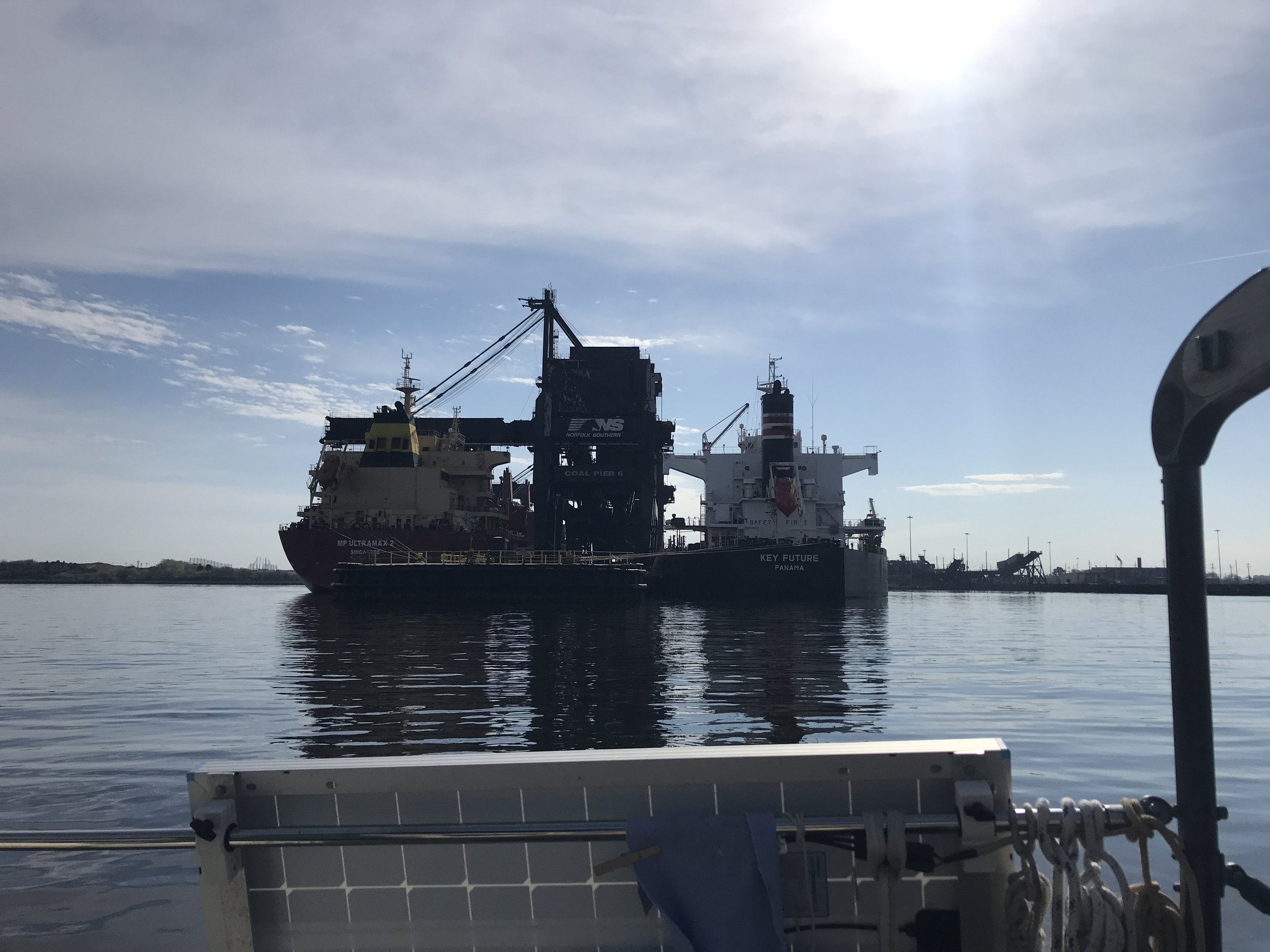
Coal loading terminal in Norfolk
Our chosen anchorage, at Davis Creek on the north side of Mobjack Bay, had mixed messages about the depths available. When we went pretty hard aground in the MIDDLE of the channel at mid-tide, we decided the reviews that said it wasn’t deep enough were accurate, and rather than seek another spot just opted to continue on another 4 hours to get to Deltaville. We dodged a LOT of crab pots!

Doing the crab pot slalom . . .
7 pm we tied up at our friends Alison and David’s dock. We made it.
All in all, it’s been just shy of 4 solid weeks of traveling to get from George Town, Bahamas, to Deltaville, Virginia, moving every single day with only 3 exceptions. We’ll find a safe spot to leave Mischief while we drive north for the eclipse.
Hopefully THAT northward journey won’t be as much of a slog as this one was!

Sunrise somewhere in North Carolina